Monday,
June 25. Corydon, IN to St. Meinrad, IN. 69 miles of riding in 5:38 hrs of
riding and bike-a-hike.

Flaming
torched today – the three H’s …heat, headwinds, hills. Did my recon on the
computer again this morning at like 5:20 AM, confirming all the twists and
turns in the route, and then writing it all out on this long cue sheet for
myself. Looked pretty hard between what I saw on the gazetteer and what I saw
on Google Earth. Matter of fact Jude saw the cue sheet and was like, “what’s
all that?” And I told her it’s the bloody route for just a portion of the day.
The other half was on a paper picnic plate! So she drove me back down to where
I left off yesterday. I gave her directions to meet me in Bristow in like 3.5
hrs and she took off to go back to the hotel to do a workout in the gym.
Got
going on a bunch of little chip seal paved roads out into Harrison-Crawford
State Forest. The scenery was just fantastic. It was pretty much like riding
around in the Cuyahoga Valley with zero traffic – but a ton of climbing. I did
see ONE solitary ADT placard today, and it was so weathered and faint that it
just looked like an old piece of plastic on a telephone pole. Other than that –
nothing. And tell ya what, like I’d said yesterday, if you don’t check this stuff
out road by road on something like Google Earth or the like, then you’re just
going into the great unknown. Heck, some of the locals haven’t even heard of
some of these roads when I stop to ask directions. And that’s my mainstay as
far as not getting hoplessly lost – ask. I did use my GPS 2x today – and it
saved me from doing a boat load of extra mileage. But it’s just so much easier
to ask some one than to dig in the pack, boot up the GPS, and then wait to see
the maps pop up. But the good thing is that when I’m just out in the middle of
nowhere, the GPS will do the trick – most of the time!!
So
I was cruising along pretty good on this Old Forest Rd, made the turn onto 462
and came into a state park where the road supposedly ended. Well, it didn’t end
on Google Earth this morning, and it didn’t end on my GPS, but the park map
said it ended. And I’m like, “ok, I can go way back and do a detour that will
add like 30 min to the ride, or just ride this damned thing down to where it’s
supposed to stop, and then jump on trail to bridge to Rt 62.” So that’s just
what I did, riding this long descent down to a horse stable area where the road
did indeed end. And just before I was getting on one of the trails I saw some
kids working over by a stable
area. So I asked them the best way to get to Rt 62, and the kid points back up
this long descent I’d just done.
“You
have to go around,” he said. And I’m like, “you’re kidding, there’s no way to
get over to 62 on a trail down here?” “Nope,” he answered, there’s a creek
you’d have to cross and it’s pretty deep and wide.” Then I pressed again about
trails. And he said I’d still have to go back up that big assed climb and then
turn into the campground area and then get on the Iron Bridge trail. “But you
still have to cross the creek on the old bridge,” he said, “and there’s no
decking on it. It just has RR rails that connect to I-beams. People do walk
across it, but I wouldn’t advise it.” Ok, I’ve done a hell of a lot worse I
told him, I’m going to give it a try. So I rode back up the climb, up and up
and up to the campground and then got on this gravel Iron Bridge Trail and
descend like hell for about 25-30 min down this horse trail. No bikes allowed!
Hey, I’m just trying to get the heck out of here, so as early as it was, with
no rangers and no horse traffic, I just blasted on through and keep it rolling.
Got
to the bottom of the trail and the main trail went off to the left and there in
front of me was the infamous iron bridge, a rickety old iron bridge that
spanned a creek for a good 50 yrds. And true to it, the thing had no planking
on it, just to big abutments on each side and then these dbl and single rails
running perpendicular to the stream, and then very thin beams joining the rails
that ran parallel to the stream. Have to admit my heart did indeed crank up 20
or more bpm when I saw the traverse I had to do. Now I did not have my big
backpack with the trail shoes so I had a choice of doing this trek with mt
biking shoes on, or in my stocking feet – shoes!! Took my sunglasses off, came
up with a strategy and got situated on the RR tracks, the dbl rails. I held the
bike by the top tube with my right hand, making sure the left pedal was at the
very back of the stroke so as not to bump into my right leg. Then I just started
to slowly shuffle, one foot on each RR rail, across the bridge.
Now
the first 40-50 feet were ok because there were big I-beam abutments every so
often to kind of rest on, but the main span, the one 40 or so feet above the
creek that went for another 200 feet or so, that had nothing but the rails
dangling above the water. There were these rotted out side rails on each side,
but I didn’t want to lean so far over with the bike in one hand that trying to
grab a rail would set me off center from the rails – all the more chance of a
cycling shoe skidding off a rail. So I just did the shuffle. Got across the
first span, and then the sketchy main span above the water. But when I can to
the span on the other side past the water, the two rails went down to one! And
I had like another 50+ feet to get to the other side. Now this was really
getting interesting. So what I ended up doing was what I didn’t want to do –
hold the bike with the left hand, and leant to the right to kind of hold the
side rail and shimmy my feet along the single rail.
Got
it. Honestly, that one was a bit heart-pounding, and I was pretty relieved when
I got over the barricade and back on my bike. So I began riding and went to put
my sunglasses on…and guess what? Yup, stupid, idiotic, moronic, *%&^%$^#
that I am - I’d left the
sunglasses on the other side of the bridge when I was scoping out how I was
going to cross. SHIT!!!!!!!!! Now I’d cycled across the country like 3 times
with those glasses – sentimental value!! Had to go back across the bridge and
get them. Just no debating it. And I did, but I didn’t take the bike!! Did the
there and back and got back to the bike still shaking my head at what a dumb
ass I was. Took it into Leavenworth and then back on more small township and
county roads.
This
is the stretch that just kicked my behind. Nothing but steep rollers for mile
after mile through Hoosier Nation Forest. The terrain was just tough as hell,
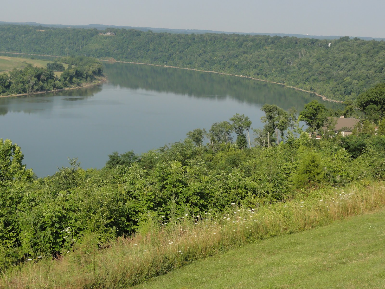
but the scenery was spectacular. There were times when I was cycling up on a
bluff hundreds of feet above the Ohio River. You could see out along the river
for what seemed to be tens of miles on each side. Used the GPS and asked for
directions a couple of time just to not waste more time, as the double bridge
traverse had taken my at least a half hour to get done. At that point I was at
the time I had told Judy that I’d meet her – and I still had a LOT more riding
to do to get to Bristow. So I had to make a decision at that point, continue on
the route I had mapped, or adjust so I could get to our meeting spot late, but
not crazy late. So instead of doing the two roads I really wanted to hit for
the day, these grave/single track sections right through this wilderness
section of Hoosier NF, I’d have to do a quicker route to get to Judy within 5
hrs of starting the ride. I’d told her 3.5 would probably do it, and I’d
grossly underestimated the time and terrain. Didn’t want her to get all wigged
out with me pulling in at 6 hrs if I were to do the backcountry section.
So
I rolled down 66 to 70 to 37 to get up to French Ridge Rd that I needed to ride
west to Bristow. By the time I got to French Ridge I was just flaming. I had
stopped in Derby for a bottle refills, and by the time I got to French Ridge I
was just about on E again with water. Man was it hot. And French Ridge Rd was
just a motha with it’s rollers and steep power climbs. Finally crawled into
Bristow with Judy parked in this abandoned auto repair place that had a sliver
of shade from a long overhanging roof. She was pretty worried, and I apologized
for not getting the time down with respect to the route. Ate two bologna
sandwiches and had an ice cold coke and then decided to just ride to St.
Meinrad to make it a day.
She
took the long route cuz we need to gas up back up on I-64 (Bristow was like a
small hamlet with zero services). And I did my last leg, about 10 miles to St.
Meinrad. I was slow as a turtle, and just really feeling the heat today.
Probably went way too long before a rest/nutrition/hydration stop. Stopped at
an American Legion in St. Meinrad to get icewater while I waited for Judy. Must
have had like 3 bottles of icewater down in there. Talked with an old gent
about cycling in the heat and he thought I was nuts. Yea, me too! Met Judy,
loaded the bike in the van and off to…get this…to Santa Claus, IN to camp at
some place called Lake Rudolph. So we got to Santa Claus and it had this
freaking “Wally World” park there. It’s really called Holiday World. I mean it
was just a total cluster*^*&#^^#. Right then and there I knew what to
expect. So we waited in a line to register – 37 bucks for an electric site -
with ten gazillion people. The campground is like part of the park, with
shuttles, buses, guides. I mean it’s insanity to the tenth power. From our
campsite here we can hear the roller coaster off to the distance, watch
shuttles packing them in and packing them out, see all these lazy folks riding
around in rental golf carts. Oh, it’s just Shangri-La for real. Beer-thirty is
staring VERY early tonight!!
So
that’s the scoop from here in lovely Santa Claus, IN. Time for a shower, a
beer, a nap, a beer, a snack….and a beer. Yup. Late……..Pete
No comments:
Post a Comment